13 April 2013 – Another Slog in the Sand

Epic!

In need of some serious sand hike training for our upcoming Fish River hike, these two caches out on Die Plaat popped into our radar.

We chose a perfect, sunny and windless day; geared up our gaiters, stocked our backpacks, packed some energy drinks and started our 15km return trek along Grotto’s sandy beach toward Die Plaat.

We found Message in a Bottle quickly amongst the most beautiful, windswept sandstone boulders, African black oyster catchers and plenty seagulls, before making our way to Duifklippe a bit further away.

Arriving at our furthest waypoint, we searched the obvious spot, but remained empty-handed.  Just imagine our disappointment as we realised the cache we have just walked 7.5kms for was no longer there!

Disappointed, we started our journey back.  As the tide had come in, we were forced to continue above the high tide mark, dutifully slogging our way back in very loose sand – Brunette cleverly walking in Blonde’s tracks…

Fortunately, our trip to Duifklippe was confirmed by fellow cacher, Strandloper3 the very next weekend and we were allowed to log our visit as a find by the cache owner!

#236 MESSAGE IN A BOTTLE (GC2GGFB)
Die Plaat Nature Reserve between Hermanus and De Kelders, South Africa

S34°27.134 E19°20.014

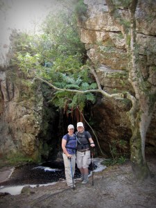
This man-made cave called Sopiesklip, was constructed by vagrant fishermen looking for a place of shelter against the wind and waves.

Visit Message in a Bottle at www.geocaching.com

#237 DUIFKLIPPE (GC2P6PE)
Die Plaat Nature Reserve between Hermanus and De Kelders, South Africa

S34°27.902 E19°20.631

We were fortunate to find plenty Black African Oystercatchers around.  This bird species are currently considered threatened with only about 5000 birds left…

Visit Duifklippe at www.geocaching.com

26 March 2013 – Picking Up the Pieces

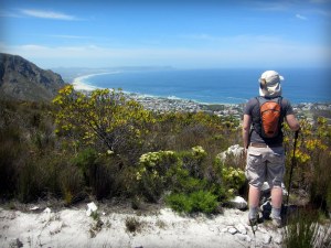
#227 WALKERBAY VIEW (GC2QGG1)
Fernkloof Nature Reserve in Hermanus, South Africa

S34°24.216 E19°17.523

Our third attempt to do the Fish River Canyon hike upcoming (weather, rain and draught finally permitting), we have started doing some short-distance, terrain-orientated caches.  Living in the Overberg, these type of caches all tend to be on the slopes of mountains, so, we are in no short supply of scenic walks and panoramic vistas…  And this one was no exception!

Following a quick slog up the mountain, we soon reached the final waypoint and that’s where the true multi-cache started!  You see, another thing about living in the Overberg is the fact that we all have at some point had the dubious experience of being involved in anything ranging from a simple walk-by ambush, or open-window vehicle raid, to a full-blown home invasion by the Overberg’s smoothest criminals, our local baboon troops!

Reaching the final waypoint, we started following a Hansel and Gretel breadcrumb route made up of colourful, somewhat melted crayons, swag, the container lid, writing utensils, and so forth…

That being the end of the fairy tale, we soon realised the mangled cache was yet another victim of a baboon raid.

Luckily, we were able to pick up most of the pieces and put Humpty Dumpty back together again…

Oh, and did I mention that we all lived happily ever after?

Visit Walkerbay View at www.geocaching.com

21 March 2013 – FTF with Flashlights

#225 CIT GOES MOGG-Y (GC47XVM)
Hemel-en-Aarde Valley near Hermanus, South Africa

S34°20.840 E19°16.562

Having to study/work really intrudes on one’s caching ability, so the Suikerbossies really jumped at the opportunity to get out of the books/work diary/emails/old questionnaires and grab a just-published cache surprisingly close to our home.

The sun was close to setting, so we rummaged through the camping-stuff container and made our pick of headlights and flashlights, entered the coords into the GPS and off we went.

Searching in the dark, we found this girly cache surprisingly quickly.  Clean log sheet and First to Find for us!

Visit CIT goes Mogg-y at www.geocaching.com


4 February 2013 – Snakes and Ladders in Fernkloof

174 Boekenhoutsbos - Keeps a Small Secret#174 BOEKENHOUTSBOS – KEEPS A SMALL SECRET
Fernkloof Nature Reserve in Hermanus, South Africa

S34°23.292 E19°16.175

Impulsive caching, is the best type of caching…

Overcast skies, a lovely ocean breeze and afternoon off – ideal for a midday hike in Fernkloof!  We started out along the joint red/green trail, but soon embarked on the more adventurous orange route along the Adder Ladder towards Boekenhoutsbos where we found our first cache for the day and the clue for our next one – a mystery cache…

Visit Boekenhoutsbos at www.geocaching.com

175 Fernkloof Vista#175 FERNKLOOF VISTA
Fernkloof Nature Reserve in Hermanus, South Africa

S34°23.250 E19°16.266

This mystery cache continued us along Adder Ladder – a winding contour path, snaking up the mountain, to a panoramic vantage point on top…

Visit Fernkloof Vista at www.geocaching.com

176 Lemoen Kop#176 LEMOEN KOP
Fernkloof Nature Reserve in Hermanus, South Africa

S34°23.698 E19°16.120

Our last cache for the day, was a quick detour to the summit of Lemoenkop before turning along the path back home.

Visit Lemoen Kop at www.geocaching.com

29 January 2013 – Ca(t)ching up with Old Friends

164 Margot & Frank#164 MARGOT AND FRANK (GC3BE10)
Along the coastal walk in Onrus, South Africa

S34°24.961 E19°10.344

Enthused to see this cache reactivated after a nine month hiatus, we found this one amidst a white shower of Pompeii-like ash, as a large veld fire was raging between Hermanus and Stanford with a gale-force Southeaster blowing clouds of smoke and ash in our direction.

A nice cache to have in our bag, as Ms Margot and Mr Frank’s younger son and his wife actually went to University with Brunette Suikerbos.

Good times….  Good times….

Visit Margot and Frank at www.geocaching.com

28 November 2012 – Flashing through Home Affairs

116 Caledons Steam Tractor

#116 CALEDON’S STEAM TRACTOR (GC10V29)
Caledon, South Africa

S34°13.720 E19°25.758

You know how one often puts things off, simply because of the hassle – this concept often involving certain government departments and their officials…?  Well, this was such an instance and, alas, Suikerbossies stand corrected!

It was time to apply for a renewal of Blonde’s passport and we both dreaded making our way to Caledon’s Home Affairs office.  Pleasant was our surprise to find a lovely air-conditioned waiting room, friendly and efficient officials, and a queue consisting of us and two other people.

So, there we were – applied, paid and finger printed – all finished within less than 30 minutes.  Have to say, will be paying our taxes, almost breaking a smile this month…

Having most of the afternoon remaining, we decided to give our nemesis – a small, magnetic nano cache located somewhere on a big green and black steam tractor, another go.

Surprisingly, as this was our third attempt at this one, Brunette found it immediately.  In our defence, we have since our previous attempts, moved on from feather-weight to hardcore cachers and were this time not bothered by the bee hive located close to the cache, nor the museum curators – a group of vagrants occasionally residing under the roofed area!

Visit Caledon’s Steam Tractor at www.geocaching.com

117 Caledon Wild Flower#117 CALEDON WILD FLOWER (GCK1WX)
Wild Flower Nature Reserve near Caledon, South Africa

S34°13.340 E19°25.690

This cache took us along a gorgeous hike in the Wild Flower Nature Reserve near Caledon and up to Window Rock – a fascinating rock formation where three boulders balance against one another to form a precarious arch over two rocky outcrops.

Absolutely amazing and worthy of a favourite point!

Visit Caledon Wild Flower at www.geocaching.com

118 The Old Way

#118 THE OLD WAY (GC1BAPG)
Along Karwyderskraal Road near Botriver, South Africa

S34°16.890 E19°11.051

We have said it before, and we will say it again – caching makes one stop where you will usually just drive by and makes you turn off where usually you will continue on.

This modified railway bridge is located on the old route between Bot River and Hermanus dating from the time prior to the R43.  It is only wide enough to allow for traffic from one direction – can only imagine the wait while the weekend traffic from the other direction took a chance and just followed the leader!

Visit The Old Way at www.geocaching.com

10 November 2012 – Finding our way through Fernkloof

090 Fernkloof Waterfall#90 FERNKLOOF WATERFALL (GC2MDZQ)
Fernkloof Nature Reserve in Hermanus, South Africa

S34°23.368 E19°16.130

Finally the rain has subsided and the summer is here – not that we are complaining about the wet winter, as the De Bos Dam is at 100% for the first time in what feels like ages!

We grabbed the pleasant weather as a hint to pack out the old hiking boots and walking sticks, and decided to set course along Fernkloof’s Klipspringer trail.

Fernkloof Nature Reserve located in the Kleinrivier Mountains above Hermanus, was proclaimed in 1957 and its 1800 hectares are home to over 1470 different species of fynbos.  The name of this principal vegetation type of the region is derived from the Dutch word “fijn bosch” which literally translates to fine bush; it is the collective name for a large variety of evergreen shrub-like plants with small, firm leaves, often rolled – but also includes certain wooded species.

Our first cache for the day was located near the Fernkloof Waterfall – almost unrecognisable in its full, cascading splendour, following the winter rains.

Visit Fernkloof Waterfall at www.geocaching.com

091 Dangerbay View

#91 DANGER POINT VIEW (GC2PWEF)
Fernkloof Nature Reserve in Hermanus, South Africa

S34°23.461 E19°15.905

Our next cache was located along an extension to the Klipspringer trail, and true to its name, we were treated to a klipspringer ram and ewe grazing peacefully along the side of the path.

Visit Danger Point View at www.geocaching.com

092 Gansbaai View#92 GANSBAAI VIEW (GC39Y0P)
Fernkloof Nature Reserve in Hermanus, South Africa

S34°23.419 E19°16.002

This one had us tricked – after finding the previous cache, we continued on all the way up to the bench on top of Kanonkop, and only checked the next cache’s GPS position AFTER having gone down again.  Turned out this cache was located a mere hundred metres from the bench further up the path.  So, had to go all the way back up again.

Luckily the spectacular view of Walker Bay was well worth it!

Visit Gansbaai View at www.geocaching.com

093 Dassies End

#93 THE DASSIES END… (GC1PZTH)
Fernkloof Nature Reserve in Hermanus, South Africa

S34°23.942 E19°15.613

Our last Fernkloof cache for the day is located near a beautiful overhang at the turn-around of the Klipspringer trail.  Rain has turned this spot into something resembling the hanging gardens of Babylon – a completely different sight to the dry, barren rock face it was a season ago…

Visit The Dassies End at www.geocaching.com

22 September 2012 – Round Trip to Caledon

067 Dassiesfontein

#67 DASSIESFONTEIN (GC23EV8)
Dassiesfontein Farm Stall along the N2 near Caledon, South Africa

S34°13.504 E19°17.788

Dassiesfontein is one of those traditional old-school farm stalls, where you are likely to find everything – from a West Coast bokkom to a leather belt; home-made jam to a wicker basket, not to mention home-baked pies, warm-out-of-the-oven farm bread and freshly brewed coffee.

We started our quick road trip with an ample serving of pepper-steak pie and coffee, before spending most of the morning browsing around the store’s many nooks and crannies.

The cache was a quick grab before setting off to the next.

Visit Dassiesfontein at www.geocaching.com

068 Take a Bath

#68 TAKE A BATH (GC10V2B)
Bath River in Caledon, South Africa

S34°13.845 E19°26.224

The next cache took us to a national monument located in the Overberg town of Caledon – a bridge dating from 1866 and built over the Baths River.

Way before the Europeans settled in this region, the local Khoi-Khoi had discovered the hot springs (or baths) in the area, Caledon is know for today.

Development started in 1710 when Ferdinand Appel secured farmland in the area, on condition that he erects a bath building allowing visitors access to the hot springs.

Like other natural springs in South Africa, the thermal springs in Caledon are not related to volcanic activity.  The water is warmed due to its flow over pressure-heated rocks deep within the earth crust and remains at a steady temperature of about 50°C.

Visit Take a Bath at www.geocaching.com

069 Hemel en Aarde

#69 HEMEL EN AARDE (GCKZBJ)
Shaw’s Pass in the Hemel-en-Aarde Valley between Caledon and Hermanus, South Africa

S34°18.708 E19°24.985

This cache is located within Shaw’s Pass on the R320.  As the pass, and in fact most of the R320, is currently undergoing construction work, it took quite a bit of off-roading with the A4 to reach it.

Due to the ongoing roadworks, the cache has since been temporarily disabled.

The ‘Bossies are certainly looking forward to the completion of this scenic route through the Hemel-en-Aarde Valley and short cut to Caledon!

Visit Hemel en Aarde at www.geocaching.com

070 Take a Break Overberg View

#70 TAKE A BREAK – OVERBERG VIEW (GC32BAE)
At a roadside stop along the N2 near Caledon, South Africa

S34°13.283 E19°18.417

Our last cache for the day was a quick park-and-grab at a scenic roadside stop along the N2.

This spot allows for panoramic views of the surrounding green wheat and yellow canola fields.  Beautiful!

Visit Take a Break – Overberg View at www.geocaching.com

This was day 28 of 30 consecutive caching days.

20 September 2012 – Zwelihle View

#64 ZWELIHLE VIEW (GC1GQHT)
Up Rotary Way near Hermanus, South Africa

S34°24.925 E19°13.111

Finding this close-to-home cache located on the mountain slope behind Mount Pleasant, has been on our list for quite awhile, however continuous roadworks along the R43 have been enough reason to delay.

We eventually managed to get onto Rotary Way, from where we followed the contour path over the neck and all along the mountain slope.

The view from the cache site was remarkable and we promptly decided this was the ideal spot to part with Clancy, the tea-drinking Swagman that have been sharing our travels since we grabbed him at the Hiddingh Security TB Hotel in Cape Town.

Visit Zwelihle View at www.geocaching.com

This was day 26 of 30 consecutive caching days.

11 September 2012 – Up and Down the Overberg

#42 MEERENSEE (GC2QFP4)
Middelvlei near Fishershaven, South Africa

S34°22.123 E19°06.731

This was an unusual cache – out there, in the middle of nowhere.

Middelvlei used to be an old farm halfway between Botriver and Hermanus, and no one really knows what could have been farmed on these sand dunes. It has since been turned into a small, private holiday resort overlooking the lagoon and mouth of the Bot River – one of the biggest bird sanctuaries in the Western Cape and home to large flocks of pelicans and flamingoes.

Visit Meerensee at www.geocaching.com

#43 ON-ZT 207 (GC1VNQV)
Onrust Mountains near Onrus, South Africa

S34°23.865 E19°11.160

This fun cache located on top of one of the Onrust Mountain peaks, was done on an impulsive whim on Brunette Suikerbos’s behalf…

Bored and with an unusual spurt of energy, our usual Lady of Leisure decided it was time for a “quick jog” up the mountain.

The “quick jog” contained a fair amount of “huffing-and-puffing”, but well worth the effort as she managed to save the Rosetta Geocoin that had been stuck in the cache for over two months.  It took a bit of gymnastics to take the self-portrait sitting on the beacon and an equal amount of skilful footwork to make it down before sunset.

Enjoyed this one, so thumbs-up with a favourite point!

Visit On-ZT 207 at www.geocaching.com

This was day 17 of 30 days of consecutive caching.